Pilot Resources
☐ Flight Plan:
- Download (SimBrief)
- Print (if desired)
☐ Obtain Crew List
☐ Download AIREP Form (if desired)
☐ Obtain Weather Charts:
- Wind Prog FL 340
- High Level Sig Prog
- Volcanic Ash Info
☐ Check Chart Change Notices/NOTAMS
☐ Review Special Qualification Airport requirements (if applicable)
☐ Current crew passports
☐ Additional WX Info:
- Central America TAFs
- Caribbean TAFs
- South America TAFs
- Station Wx, NOTAMS, Field Report
☐ General Declarations (if required)
☐ Customs Declarations forms (if required)
☐ Water/LAV Service . . . . . . . . . . . . . . . . . . . . . . . . . . . . . . . Verify accomplished
☐ Verify security search
Warning: Ensure the aircraft is not being fueled before performing HF check
☐ Perform HF 1 and 2 (as installed) radio check, tone of any length is acceptable
☐ ACARS FFD (if required)
☐ Update winds when new updates become available (0500z, 1100z, 1700z, 2300z)
☐ Perform Navigation Accuracy Check
☐ Review Jeppesen country pages
Position Reports (if ADS is Unavailable)
Use AIREP Form as a reference for the phraseology and order for making position reports.
☐ Report each compulsory fix (filled-in solid waypoints only):
- aircraft ID/position/time/flight level
- next compulsory fix/ETA
- next compulsory fix
If ![]() symbol located at fix: meteorological report required (temperature, wind, any significant weather)
symbol located at fix: meteorological report required (temperature, wind, any significant weather)
Prior to FIR Boundary
☐ CPDLC/ADS (if installed), LOGON with New York (KZWY) oceanic:
- ATC COM > CONNECTION > NOTIFICATION
- Enter KZWY [2L]
- Press NOTIFY* [2R]
NOTE: Successful LOGON will display "ACTIVE ATC-KZWY"
☐ Refer to JeppFD-Pro Route Info > Communication Procedures for FIR crossing notification.
Oceanic Entry Point
☐ SLOP (if desired) - offset 1 nm right of centerline or 2 nm right of centerline as desired
Oceanic Exit Point
☐ If applicable, communicate acceptance/rejection of re-dispatch message
NOTE: Re-dispatch may be received up to 2 hours prior; however, if not received within one hour from re-dispatch point, contact the dispatcher.
☐ Ensure SLOP is zero by oceanic exit point
Diversion Airports
☐ Continually evaluate weather for enroute diversion airports and arrival routings
Weather Radar
☐ Ensure weather radar ON during IMC or night
Communication
☐ HF SELCAL check (if required)
Arrival Briefing
☐ Review airport specific 10-7 page unique engine failure during missed approach procedures
☐ Review transition altitude, country, and airport specific speed restrictions
Air-to-Air . . . . . . . . . . . . . . . . . . . . . . . 123.45
Caribbean . . . . . . . . . . . . . . . . . . . . . . 130.7
WATRS . . . . . . . . . . . . . . . . . . . . . . . . . 129.9 (southbound) / 130.7 (northbound)
Distress
VHF . . . . . . . . . . . . . . . . . . . . . . . . . . . . 121.5
HF . . . . . . . . . . . . . . . . . . . . . . . . . . . . . 2182 / 8364
XPDR . . . . . . . . . . . . . . . . . . . . . . . . . . 7700 (Emergency) / 7600 (Lost Communications)
ATC Communications
CAR-A . . . . . . . . . . . . . . . . . . . . . . . . . . 2887, 3455, 5550, 6577, 8846, 11396
CAR-B . . . . . . . . . . . . . . . . . . . . . . . . . . 5520, 6586, 8918, 11330 , 13297, 17907, 21985
West Atlantic Route System (WATRS) Airspace
The clearance received at the departing station (voice, CPDLC, or ACARDS DCL) is a valid clearance through WATRS airspace.
-
ATC will assign an altitude and Mach# prior to oceanic entry point
- NOTE: These two items plus the predeparture clearance routing constitute a valid clearance
- Transponder: leave on last assigned squawk code for the entire duration of WATRS
- SLOP: see Strategic Lateral Offset Procedure (SLOP) below
NY Radio (ARINC)
NOTE: New York Radio is not ATC, they are simply a radio operators that relay incoming communications to ATC.
- Check in on 129.9 (southbound) or 130.7 (northbound) when directed with requested Mach, altitude, and estimate for WATRS entrance point.
- NY Radio will assign HF frequencies.
- Complete HF SELCAL check.
East Coast Route Restrictions
Non-ETOPS:
On L462 between 25N and 26N, do not accept re-routes or deviate east of the airway except when exercising emergency authority.
A32F (Except A321E and A321H):
In addition to the restriction above, do not plan or accept a re-route on L461 or (L458/L459 between 24N and 26N).
SLOP is a standard operating procedure for the entire region. The options are centerline, 1 nm to the right, or 2 nm to the right. TCAS may be useful in selecting SLOP.
- Offset using NAV, not heading select.
- Do not advise ATC or request ATC clearance.
- Return to course by oceanic exit point.
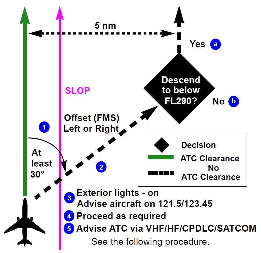
If immediate action is not required, request a revised ATC clearance. If prior clearance cannot be obtained, accomplish the following until a revised clearance is received:
- Turn at least 30° to the left or right in order to intercept a 5 nm offset parallel track.
-
Maintain FL if able or minimize climb/descent rate. Once established on a 5 nm parallel, same direction track/route offset, accomplish either:
-
Descend below FL290 (recommended) and once below FL290: establish/maintain an altitude that differs by 500 feet from altitudes normally used.
NOTE: Descent below FL290 is particularly applicable to operations where there is a predominant traffic flow (e.g., east-west) or parallel track system where the aircraft’s diversion path will likely cross adjacent tracks or routes.
The descent can decrease the likelihood of conflicts with other aircraft, TCAS RA events, and delays in obtaining a revised ATC clearance. -
Climb/descend 500 feet and maintain an altitude that differs by 500 feet from altitudes normally used.
Caution: Altimetry system error may lead to less than actual 500 feet vertical separation and TCAS RAs may occur.
-
- Turn exterior lights on and advise other aircraft on 121.5/123.45 “mayday or pan-pan” (as appropriate).
- Proceed as required by the operational situation or ATC clearance (if obtained).
- Advise ATC: “mayday or pan-pan” (as appropriate) using CPDLC, SATCOM, or 121.5.
- Request weather deviation clearance from ATC.
-
If clearance is denied or no communication is established and if the deviation is:
- 5 nm or less: remain at ATC assigned FL
-
is greater than 5 nm either:
- turn north and descend 300 feet or
- turn south and climb 300 feet
-
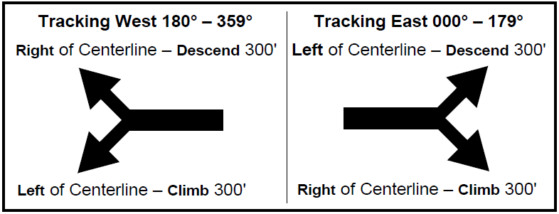
- Climb or descent mandatory if deviation beyond 5 nm is necessary.
- When returning to route/track, be at assigned FL when within 5 nm of centerline.